
Most Downloaded Plugins
List of approved plugins sorted by the number of downloads.
2177 records found

nmea2qgis2
load nmea file to qgis 2.0
2013-10-19T08:48:39.244407+00:00

Processing PS Tools provider
Expose PS Tools to Processing.
2018-09-08T09:40:54.162591+00:00

Spatial Data Analysis for Point Pattern
SDA4PP with R functions. Requires R, RPy2 and R packages; rgdal, maptools, spatstat.
2012-05-15T07:45:20.834067+00:00

ROIExplorer
QGIS Plugin for exploring the spectral signatures of ROIs
2015-10-07T12:20:07.847506+00:00

OpenLog
High performance drillhole visualization QGIS module supporting 3D, cross-section, and log views.
2024-07-19T07:40:00.371659+00:00

FilterMate
FilterMate is a Qgis plugin, a daily companion that allows you to easily explore, filter and export vector data
2024-03-19T21:43:47.549993+00:00

Weißflächenkartierung
The White Space Mapping Tool provides an innovative and customizable approach to identifying potential areas for the installation of solar …
2024-04-12T08:49:40.890697+00:00

MultiJoin
Join in a new layer n fields taken from other n layer having the same field
2022-07-04T07:33:56.071287+00:00

WNT Open Source 3
A toolbox for water utility providers for QGIS 3.
2018-02-06T16:03:11.125930+00:00

Lizard Viewer
This plug-in helps with downloading data from Lizard in QGIS.
2017-10-19T14:46:42.624973+00:00

Repair Lines Connections
repairs the connection of lines, each error is repaired individually through the user's confirmation
2019-02-15T12:48:50.298220+00:00

SpatialDataPackageExport
Spatial Data Package Export plugin
2021-07-19T09:44:58.705322+00:00

China Transform Tool
shp\img文件坐标系转换工具,支持WGS84\GCJ02\BD09坐标系转换 SHP\IMG file coordinate system conversion tool, support WGS84\GCJ02\BD09 coordinate system conversion
2021-05-04T01:54:14.656986+00:00

Open Aerial Map (OAM) for QGIS3, Express Edition
Open Aerial Map (OAM) client for QGIS3, Express Edition
2021-05-06T03:44:52.535960+00:00
qgissprp
A simple photogrammetry route planner.
2021-05-17T09:19:50.264435+00:00

TRMM Data Downloader
Download and aggregate TRMM data to create thematic maps.
2015-11-16T10:03:38.219647+00:00

Selection Sets
Plugin for saving and loading selection sets for layers.
2016-03-04T04:50:50.038611+00:00

NatusferaQGIS 3
Harvest biodiversity observations from Natusfera.
2018-04-03T15:34:13.861875+00:00
Geometry Wrapper
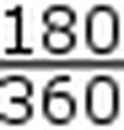
Converts geometry longitude from [-180,180] to [0,360] and vice versa
2019-11-19T03:48:37.767522+00:00

Quick STEP
Accuracy assessment of object-based image classification - GEOBIA
2016-05-30T03:55:58.246899+00:00
| Name | Author | Latest Version | Created On | Stars (votes) | ||||
|---|---|---|---|---|---|---|---|---|
|
|
nmea2qgis2 | 4,757 | Maciej Olszewski | 2013-10-19T08:48:39.244407+00:00 | 2013-10-19T08:48:36.406387+00:00 |
(22)
|
— | 0.1 |
|
|
Processing PS Tools provider | 4,741 | Riccardo Lemmi (for Faunalia) | 2018-09-08T09:40:54.162591+00:00 | 2014-11-18T17:41:06.415460+00:00 |
(0)
|
— | 0.2.3 |
|
|
Spatial Data Analysis for Point Pattern | 4,734 | Kepoglu | 2012-05-15T07:45:20.834067+00:00 | 2012-05-14T20:58:54.328453+00:00 |
(11)
|
— | 0.201 |
|
|
ROIExplorer | 4,731 | Eric Bullock, Chris Holden | 2015-10-07T12:20:07.847506+00:00 | 2015-09-21T21:12:46.076324+00:00 |
(8)
|
— | 0.1.1 |
|
|
OpenLog | 4,731 | Apeiron | 2024-07-19T07:40:00.371659+00:00 | 2024-01-31T16:34:42.348122+00:00 |
(5)
|
1.2.2 | — |
|
|
FilterMate | 4,723 | imagodata | 2024-03-19T21:43:47.549993+00:00 | 2023-11-21T16:05:55.310429+00:00 |
(8)
|
1.8 | — |
|
|
Weißflächenkartierung | 4,717 | CISS TDI GmbH | 2024-04-12T08:49:40.890697+00:00 | 2021-02-22T14:43:06.532609+00:00 |
(53)
|
3.2.1 | — |
|
|
MultiJoin | 4,697 | Giulio Fattori | 2022-07-04T07:33:56.071287+00:00 | 2022-07-04T07:33:55.712582+00:00 |
(4)
|
1.0 | — |
|
|
WNT Open Source 3 | 4,694 | GCI | 2018-02-06T16:03:11.125930+00:00 | 2018-02-06T16:03:09.800118+00:00 |
(2)
|
— | 0.1 |
|
|
Lizard Viewer | 4,693 | Madeleine van Winkel | 2017-10-19T14:46:42.624973+00:00 | 2017-06-09T08:07:32.590670+00:00 |
(4)
|
— | 0.10 |
|
|
Repair Lines Connections | 4,690 | Carlos Eduardo Cagna | 2019-02-15T12:48:50.298220+00:00 | 2018-05-18T20:08:48.930391+00:00 |
(0)
|
1.0.2 | 0.11 |
|
|
SpatialDataPackageExport | 4,688 | Gispo Ltd. | 2021-07-19T09:44:58.705322+00:00 | 2020-10-14T21:14:47.886790+00:00 |
(1)
|
0.2.1 | 0.1.0 |
|
|
China Transform Tool | 4,682 | wudaojian | 2021-05-04T01:54:14.656986+00:00 | 2021-05-04T01:54:12.916700+00:00 |
(9)
|
— | 0.1 |
|
|
Open Aerial Map (OAM) for QGIS3, Express Edition | 4,681 | yojiyojiyoji | 2021-05-06T03:44:52.535960+00:00 | 2021-05-06T03:44:50.341840+00:00 |
(0)
|
— | 0.1.0 |
|
|
qgissprp | 4,664 | Xiangyong Luo | 2021-05-17T09:19:50.264435+00:00 | 2021-05-10T12:31:19.739888+00:00 |
(5)
|
0.5.0 | — |
|
|
TRMM Data Downloader | 4,653 | Geobricks.org | 2015-11-16T10:03:38.219647+00:00 | 2015-10-27T12:49:36.835237+00:00 |
(11)
|
— | 0.2 |
|
|
Selection Sets | 4,652 | Nathan Woodrow | 2016-03-04T04:50:50.038611+00:00 | 2016-03-04T04:50:49.370140+00:00 |
(4)
|
1.0 | — |
|
|
NatusferaQGIS 3 | 4,633 | Alex Vilanova | 2018-04-03T15:34:13.861875+00:00 | 2018-04-03T15:34:13.116654+00:00 |
(1)
|
1.0 | — |
|
|
Geometry Wrapper | 4,597 | Jonah Sullivan | 2019-11-19T03:48:37.767522+00:00 | 2017-03-20T20:58:02.896946+00:00 |
(4)
|
— | 0.45 |
|
|
Quick STEP | 4,597 | Salomón Ramírez, Ivan Lizarazo | 2016-05-30T03:55:58.246899+00:00 | 2016-05-30T03:55:57.643113+00:00 |
(18)
|
0.1 | — |


